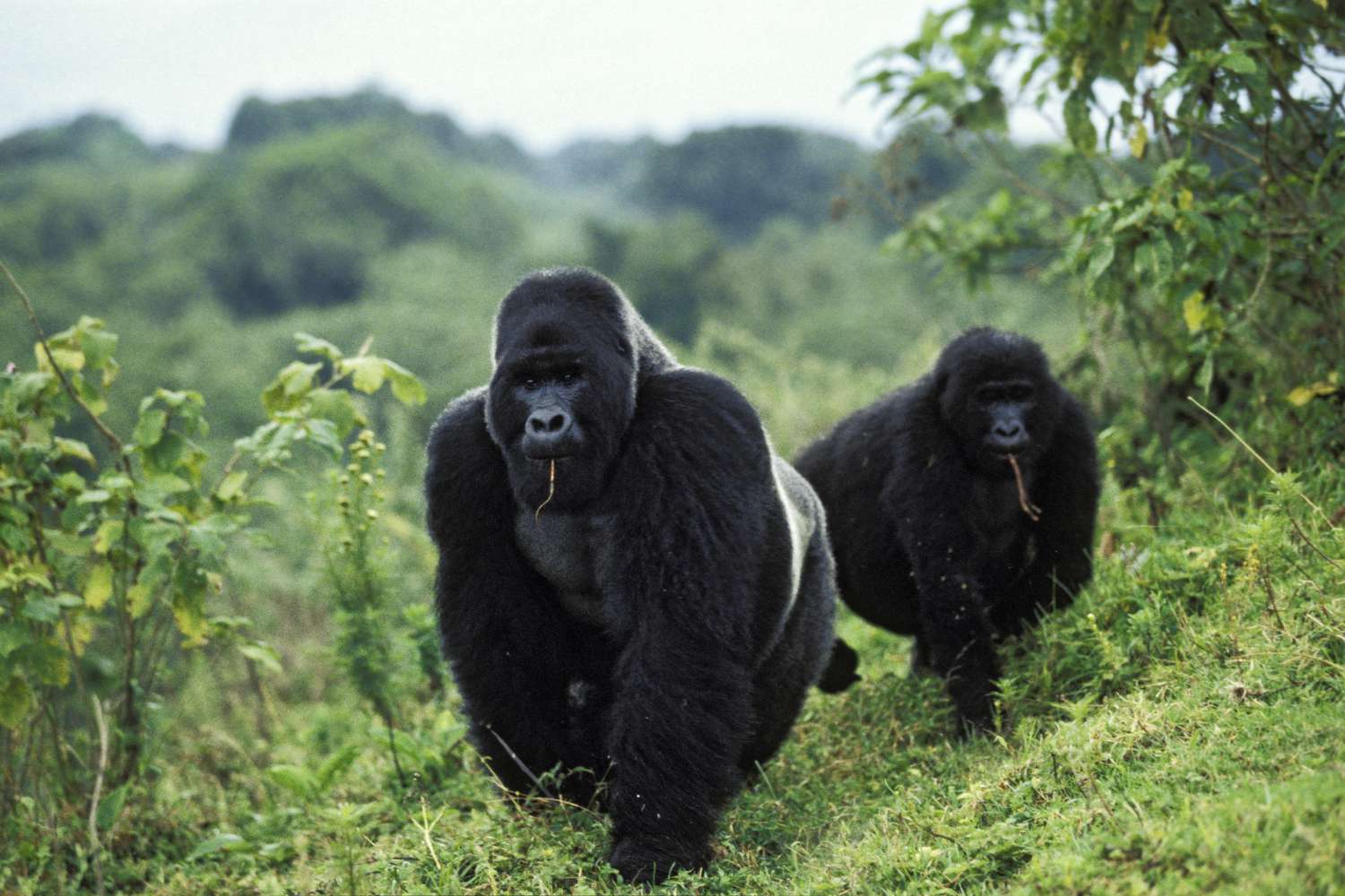
Mountain Gorilla Trekking in Rwanda is an exceptional activity that attracts most of visitors to…
Congo Nile Trail – Everything You Need to Know
Congo Nile Trail – Everything You Need to Know
To help other travelers, I’ve taken the liberty to consolidate all the information about Congo trail Congo Nile Trail – Everything You Need to Know. I collected before and during my tour along the Congo Nile Trail in Western Rwanda. This post includes general information on the trail, maps (with distance and elevation), guesthouse and campsite information, GPS tracks, and bike rental information. Hope this can be of use to others as they plan their hike or cycling trip!
The Basics:
The co trail is well-marked with frequent villages, shops and guesthouses/campsites. The trail primarily follows rocky, dirt roads that wind up and around the numerous hills between Gisenyi and Kamembe.
Do not expect a pleasant rural single track – you will be sharing the road with moto traffic and the occasional Primus delivery truck or minibus.
There are a few long climbs, but the gradient is quite gradual. You are constantly ascending and descending between 1450 and 1800 meters.
Food and Water on the congo Nile trail.Both are available throughout the entire trail. You are never more than 5-10 km from a village with a drink shop. For newcomers to Rwanda, like myself, you might not immediately recognize shops in village centers – they are not always obvious . Simply look for an MTN, Tigo or Primus sign and glance in the door; usually these shopkeepers will sell an array of goods. Congo Nile Trail – Everything You Need to Know
Since most days are relatively short, I took snacks with me to eat at the top of hills and ate meals at my destination.
I enjoyed excellent meals everywhere I stopped, including homemade pizza and pina coladas at L’Esperance and delicious sambaza and rice at Kinunu Guesthouse.
Sleeping
You don’t need a tent for this trail. RDB has setup numerous campsites, but you’ll need your own gear. These campsites are well-marked and do not need to be booked in advance. I planned my route so that I cycled around 3-6 hours/day and reached a guesthouse.
The trail from Kinunu to Kibuye is the hardest and longest day, but can be done in 4-6 hours if you don’t have major bike maintenance issues (like my Swiss companions).
I spent a day with a friend and his former Peace Corps host family in Tyazo, so I didn’t make it all the way to Kamembe (30 km after Buhingo on the main road). Here is a list of guesthouses on the trail:
I have marked all of these, as well as the campsites, in my GPS tracks at the bottom of this post. You should book guesthouses in Kibuye and at L’Esparance, as both tend to be popular.
The latter has ample tents and campsites should all their rooms be full.
Gear – I traveled light with just the following items: sleep sack, Nalgene bottle, small bike pump, extra tire, patch kit, one jersey, one change of clothes, toiletries, headlamp, sunscreen, books, roll up coat – Congo Nile Trail – Everything You Need to Know
(it gets cold at night), dust mask, scarf, and assorted snacks (nuts + fruit). If you are camping, I’d recommend a 40-50 degree F bag, as it will usually drop into the 50’s at night and there can be a gentle breeze.
Bicycle Rental/Purchase
I was fortunate enough to borrow a bike from a friend in Kigali. I encourage you to shop around a bit and reach out to the various parties mentioned – better yet, try out the bikes for yourself to see what best matches your needs. Since it is expensive and difficult to import bicycles, quality cary vary widely.
Rwandan Adventures (Rwandan Adventure Cycles) and Inzu Lodge, both in Gisenyi, can arrange for rentals that include panniers, racks and spare parts. RA charges $30/day ($75/week) for sturdy (if heavy) locally-made Rwanda Adventure Cycles 21-speed mountain bike without shocks. A number of people have ridden their bikes around Rwanda, Goma and even elsewhere in Africa. As well, through its self-guided bike tour rentals and full adventure tours, RA also supports a number of worthy social projects. A few individuals I saw at Inzu Lodge rented very nice Giant mountain bikes – not sure about the price point.
Bike rentals
There are a few options in Kigali for bike rentals, including TR Companion, which rents nice-looking German Focus Cypress mountain bikes for $25/day. For purchases, keep an eye on Living in Kigali forum and/or bargain with the used bike sellers near Nyambugogo bus station where, I purchased a basic mountain bike from one of the traders for under $200 and added a rack for an extra $10.
Itinerary Options – for the Congo trail – I would recommend starting in Gisenyi and heading south to end in Kamembe. If you don’t have time to complete the full 5-day trip, you can opt for the most beautiful portion from Gisenyi to Kibuye. This can be completed in one long 120 km day or two easy days with a stop in Kinunu.
There is a three-hour 2,000RWF boat that goes from Kibuye to Gisenyi two times a week, which would allow you to return your rental bicycle. Rwandan Adventures can help to arrange this 2-day bike and boat trip. Congo Nile Trail – Everything You Need to Know
Transport to/from the Trail – Kigali Safari and Belvedere bus companies were the most accommodating with my bicycle. I paid for the back four seats in the bus for the bicycle and one seat for myself (3,000RWF/seat) on the 3.5 hour trip from Kigali to Gisenyi. The 5.5 hour trip from Kamembe to Kigali was 5,000RWF/seat.
Websites & Blogs:
The Rwanda Development Board’s website is largely useless, and my visit to their offices yielded no information or map. While preparing for my trip, I relied largely on two excellent blog posts:
Map:
RDB has produced a nice map, but it was unavailable in Kigali in June/July. Luckily, I came across a copy at Inzu Lodge in Gisenyi. I’ve taken a few high-quality photos of the map below:
The map is not entirely accurate when it comes to elevations and distances. Below are the approximate distances between the villages where I stopped:
- Gisenyi to Kinunu – 50 km
- Kinunu to Kibuye – 70 km
- Kibuye to Mugonero – 30 km
- Mugonero to Kibogora – 35 km
- Kibogora to Kamembe – 60 km
The first day features the steepest elevation climb. However, Day 2 on the road to Kibuye, has the most hills spread out over 70 or so kilometers – definitely the most taxing day.
Day 3 to Mugonero is short, but incorporates the highest climb of the trip to 1,887 meters. On Day 4, you rapidly descend to 1,440 meters, (Lake Kivu level) and climb back up to 1,750 meters over 10+ kilometers. Day 5 is easy – you’re on beautiful new tarmac road and there are only minor rolling hills.
GPS Tracks on the Congo Nile trail.
You definitely do not need a GPS, as the trail is relatively well-marked and there are people everywhere that can help you with direction. (do not, however, trust their feedback on if there are hills/mountains up the road). Alternatively, the RDB map is sufficient for most travelers.
You can check-out my GPS tracks here at Garmin Connect. (the Garmin Player version is the best viewing option).
I marked waypoints for all the major villages, campsites, attractions and guesthouses. Some of these do not appear on the RDB map above. therefore, a pair of German travelers also produced these tracks that run all the way from Gisenyi to Nyungwe National Park.
Side Adventures:
If you want to spice things up and getting off the main trail, would recommend heading east from Kibogora.
n a small valley path that leads into Nyungwe National Park. Alternatively, there is a trail from Nkora village and/or Kinunu Village that cuts through Gishwati Protected Forest. One of my friends said, that this was amongst his top three favorite rides in Rwanda Congo Nile Trail – Everything You Need to Know If I were back in Rwanda, I’d also consider a multi-day kayaking trip along the shores of Lake Kivu.
Related Posts